Second Homes in Colorado Springs
Pikes Peak, big-city amenities, and a wide range of neighborhoods.
- County
- El Paso (county seat)
- Elevation
- 6,035 ft
- Population
- About 495,000
- Downtown Denver
- 69 mi · about 1 hr 5 min
- Pikes Peak
- 19-mi toll highway from Cascade
- Schools
- Several districts (D11, D20, D12, D2, D49)
Drive times are typical and change with traffic and weather.
Living in Colorado Springs
What it's like to live in Colorado Springs
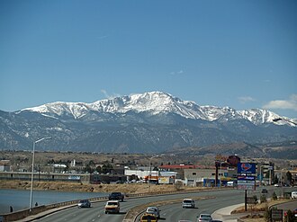
Colorado Springs is El Paso County's seat and its largest city, with about 495,000 people at the foot of Pikes Peak. It gets about 243 sunny days a year, and warm chinook winds are normal in winter. Garden of the Gods and the mountains sit right on the city's west edge.
The military has a big presence here, with Fort Carson, Peterson and Schriever Space Force Bases, Cheyenne Mountain, and the Air Force Academy. That keeps a steady stream of buyers and sellers moving in and out.
Neighborhoods vary a lot: historic west-side streets in Old Colorado City, established wooded areas near the Broadmoor and Cheyenne Canon, and newer master-planned communities on the north end around Briargate, Northgate, and Flying Horse. It suits buyers who want city services and a real job market with mountain trails minutes away.
Where it is
Where Colorado Springs sits on the Front Range
Hover a pin for a quick look. Click to open that town's guide.
Neighborhoods
Where to look in Colorado Springs
Broadmoor
Southwest Colorado Springs around the historic Broadmoor hotel, with hilly, wooded streets climbing toward Cheyenne Mountain. Served by Cheyenne Mountain District 12.
Cheyenne Canon and Ivywild
Southwest neighborhoods with wooded creekside lots, trails, and the 1916 Ivywild School, now a community hub.
Old Colorado City
The west side's historic core, founded in 1859, with a commercial district along Colorado Avenue on the National Register.
Briargate
A north-side community along Academy Boulevard near the Air Force Academy, served by Academy District 20.
Northgate
A growing area east of the Air Force Academy near I-25, mixing newer neighborhoods with older ranches and horse properties.
Flying Horse
A master-planned community on the north end built around the private Club at Flying Horse, served by Academy District 20.
Get outside
Things to do in Colorado Springs
- 01
Garden of the Gods
A free National Natural Landmark on the west edge with 300-foot red sandstone formations.
- 02
Pikes Peak Highway
A 19-mile paved road from Cascade to the 14,115-foot summit. Summer reservations are required.
- 03
Cheyenne Mountain Zoo
A zoo on the slopes of Cheyenne Mountain above the Broadmoor neighborhood.
- 04
Old Colorado City
Victorian-era buildings along Colorado Avenue, now shops, galleries, and restaurants.
- 05
Ivywild School
A 1916 schoolhouse reopened with a brewery, bakery, deli, and concert venue.
- 06
Pikes Peak International Hill Climb
A race to the summit held every year on the last Sunday of June.
Know about Colorado Springs homes before everyone else does.
Listing alerts for Colorado Springs and nearby foothill towns. Free, and you can stop anytime.
Latest from Colorado Springs
Articles
FAQ
Colorado Springs questions, answered
How far is Colorado Springs from Denver?
About 69 miles on I-25, a little over an hour without heavy traffic.
What county is Colorado Springs in?
El Paso County. Colorado Springs is the county seat.
What is the elevation of Colorado Springs?
About 6,035 feet downtown, and higher toward the foothills on the west side.
What school district would I be in?
It depends on the address. The city is split among several districts, including D11, Academy D20, Cheyenne Mountain D12, Harrison D2, and Falcon D49.
What is the weather like?
Sunny most of the year, with about 38 inches of snow a season and frequent summer afternoon storms.
How do I get to the top of Pikes Peak?
Drive the 19-mile Pikes Peak Highway from Cascade, just west of town, and plan two to three hours round trip.
Nearby